QRRC Data Support
The task of finding contextual data to support research is sometimes time-consuming, so we have put together what we hope will be a useful selection of links relating to the Quesnel River Basin (QRB). If you are seeking other data, please ask us. The page describing the characteristics of the Quesnel watershed also provides a series of maps illustrating the basin's attributes.
Please note that this is an information service only: no claims are made as to the current status or fitness for purpose of any dataset. All links are live as of March 2017.
- Elevation
- Hydrology
- Land-Cover / Ecology
- Limnology / Water Quality
- NTS Maps
- Remotely-Sensed Imagery
- Sub-Surface (Soils / Geology)
- Weather / Climate
- Wildlife Habitat
- Socio-Economic Data
Elevation Data
- The QRRC has access to the BC Terrain Resource Information Management (TRIM) Digital Elevation Model (25 m spatial resolution), and may be able to make this available to partners in bona fide collaborative projects. An open-access version converted to the Canadian Digital Elevation Data format is available for download here.
- Another option is the HydroSheds DEM, distributed by the USGS. This includes a range of useful products based on the Shuttle Radar Topography Mission (SRTM) at 3 arc-second spatial resolution (approximately 56 m at the QRRC's latitude of ~52.6°N). Tile N50W125 contains the QRB. A topographic map of the QRB generated using this dataset is available for download here.
- The Canadian Digital Elevation Model and Canadian Digital Surface Model are also available through GeoGratis.
Hydrological Data
- The BC Freshwater Atlas provides a variety of spatial data describing watersheds, lakes, rivers, wetlands and other features. ShapeFiles are available for direct download here.
- The comprehensive National Hydro Network dataset is available for download in ShapeFile format from GeoGratis for the Horsefly, Quesnel and Cariboo watersheds.
- Hydrometric data are collected in the QRB by the Water Survey of Canada (WSC) at the following active gauges:
- Quesnel River at Likely (08KH001), since 1924 (near real-time)
- Quesnel River near Quesnel (08KH006), since 1939 (near real-time)
- Horsefly River above McKinley Creek (08KH010), since 1955 (near real-time)
- Quesnel Lake near Likely (08KH011), since 1956 (near real-time)
- Penfold Creek near the mouth (08KH030), since 1998 (near real-time)
- Moffat Creek near Horsefly (08KH019), since 1964
- McKinley Creek below outlet of McKinley Lake (08KH020), since 1945
- Camp Creek near the mouth (08KH029), since 1998
- Horsefly River above Quesnel Lake (08KH031), since 2004
- The locations of these gauges are mapped over a Landsat 8 Operational Land Imager (OLI) image, below.
- Data-files for these, and also for inactive gauges, are available for download from the ECCC-WSC data-products page, as is the complete HYDAT database.
- The Cariboo Water Tool provides a map of the gauges, with links to various options for hydrometric reporting.
- A list of all active and inactive gauges in the QRB, including their locations and periods of record, is available in comma-separated format here: QRB Gauges (please note that a 'YEAR_TO' value of 2017 corresponds to gauges active as of March 2017).
Land-Cover / Ecology
A variety of 'snapshot' spatial datasets describing vegetation and ecological zones is available, as well as products based on the MODIS satellite-borne sensors. We are able to help with sourcing clipped extents of these products covering the QRB.
- The BC Bio-Geo-Climatic Ecological Classification (BEC) is available as a ShapeFile (polygons) here. We have prepared a map of zones represented in the QRB.
- Details of the provincial Vegetation Resource Inventory (VRI) are posted here and here, and the full GeoDatabase (3.9 Gb) is available for download here.
- The 2010 release of the North American Land-Cover (NALC) is available in raster format at 250 m spatial resolution from the Commission for Environmental Co-operation. A map of classes represented in the QRB is available here.
Limnology / Water Quality
The QRRC has been taking regular conductivity-temperature-depth (CTD) observations at a series of locations in Quesnel Lake and some other water bodies for several years. While these data are somewhat sensitive, as they form the inputs for current active research related to the 2014 breach of the tailings pond at the Mount Polley Mine, it may be possible to arrange access to them on agreement of appropriate conditions.
Other related measurements include a range of aquatic and sedimentological metrics taken from the Quesnel River by a variety of methods, including sondes and manual sampling.
Please contact Dr Phil Owens or Dr Ellen Petticrew for more information about these datasets.
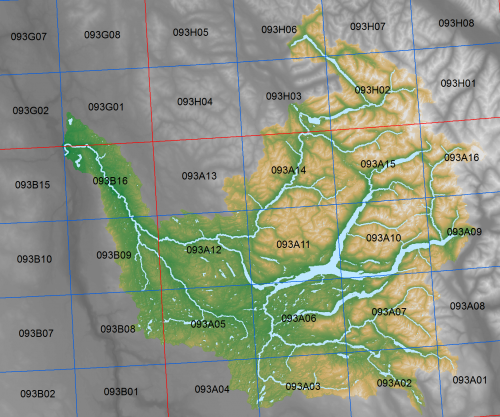
NTS Maps
- Traditional 1:50,000 and 1:250,000 scale maps are available as individual tiles in PDF and raster format from the Natural Resources of Canada CanMatrix server and GeoGratis.
- Vector datasets representing the various components represented on NTS maps are available here.
- The image below shows the 1:50k and 1:250k sheets covering the QRB.
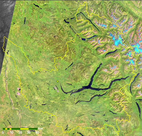
Remotely-Sensed (Satellite) Imagery
- Imagery from sensors on the Landsat series is available from the USGS EarthExplorer site. The QRB is most often to be found in tiles identified by path 46, 47 or 48, and row 23 or 24. The false-colour image below shows a view from the Operational Land Imager (OLI) on Landsat8 taken on 19th August 2016. The QRRC is shown as a yellow and green diamond, near the outlet (western end) of Quesnel Lake.
- Imagery from the MODIS sensors on the Terra and Aqua platforms is available primarily from the Land Processes Distributed Archive Center, or National Snow and Ice Data Center. The QRB is in tile h10v03.
Sub-Surface: Soils / Geology
- The QRB spans four of the fundamental units of BC's deep structural geology - the Cariboo (Cassiar), Kootenay, Quesnellia and Cache Creek terranes. A spatial dataset defining these is available for download from the BC Ministry of Energy and Mines, here.
- The BC Geological Survey's comprehensive spatial dataset of solid geology, together with major faults and surficial deposits, is also available for download from their web-site. The page with more detail specific to the QRB is here.
- An excerpt map of the QRB's geology, depicting era and principal rock type, is available for download here. A list of all distinct geological units found in the QRB, together with brief descriptions, is also available for download in Excel and Adobe Acrobat formats.
- Details of the BC Soils Information System are posted here, together with a link to the full spatial dataset.
- The Ministry of Energy and Mines' page of Geospatial Data Downloads provides a useful compendium of related datasets.
Weather / Climate
- Data collected at the Cariboo Alpine MesoNet weather stations may be available by request from Dr Stephen Déry.
- A near-real-time summary of weather conditions at the QRRC over the past five days is available here.
- The map below shows stations in (and adjacent to) the QRB, as well as nearby automatic snow-pillows and active hydrometric gauges.
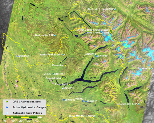
(full-size version - 8.5 mb)
- The BC River Forecast Centre collates near real-time measurements of snow-water equivalent from its network of automated snow pillows. The following ASPs are in or close to the QRB -
- A comprehensive directory of other meteorological stations is available from the Pacific Climate Impacts Consortium data portal.
- The Climate WNA / BC site provides access to a range of climatological data downscaled using an implementation of the PRISM methodology.
Wildlife Habitat
- Spatial datasets defining approved habitat areas for 'at-risk' and regionally important species are available here.
Socio-Economic Data
- The QRB is largely within Area F of the Cariboo Regional District (see map).
- Census data describing a range of socio-economic indicators is available through BC Stats and Statistics Canada (as are all levels of boundary file).