Investigating the Impacts of Landscape Disturbances on Sediment and Contaminant Fluxes: Phases 1 and 2: Results
Phase 1
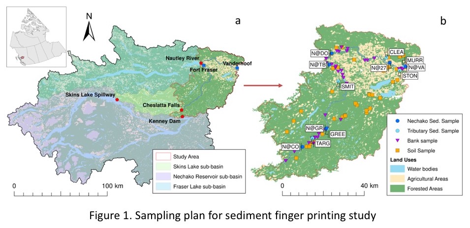
Given that the Nechako River watershed is so large, we decided to focus our efforts on a smaller sampling area. We chose to include the mainstem of the Nechako upstream of Vanderhoof and also included most of the sub-basins along the mainstem up to the Kenny Dam due, in part, to the distribution of Nechako River white sturgeon. We sampled suspended sediments at six sites on the mainstem of the Nechako as well as nine tributaries (Figure 1).


Our sediment fingerprinting research has been able to demonstrate that the main sediment sources for the samples collected at Vanderhoof vary over the field season and that the times of contributions from the erosion of channel bank material matches well the hydrograph (Figure 2). To see full details of our research relating to the sediment fingerprinting in Phase 1 of our research, please click here.
While there has been much interest and focus on sediment sources to the mainstem Nechako River, we have received queries from stakeholders regarding whether sediments in the basin are potentially contaminated with legacy and emerging chemical pollutants including current-use herbicides and pesticides. The concerns raised have included the potential adverse impacts of pollutants on human health as well has the potential affects on regional freshwater ecosystems that support anadromous salmon and the endangered Nechako white sturgeon population.

Todd French collecting bottom sediments near Fort Fraser, BC
The objective of this part of the study was to assess the chemical quality of suspended and channel bottom sediments within the context of polychlorinated biphenyls (PCBs), polybrominated diphenyl ether (PBDEs) flame retardants, legacy organochlorine (OC) pesticides, polycyclic aromatic hydrocarbons (PAHs), organophosphorus and phenoxy acid herbicides, and labile (exchangeable) metals/metalloids that are associated with toxicity. We also synthesized historical (1980s to 1998) datasets for organic and inorganic pollutants in Nechako River watershed sediments (Figure 1).

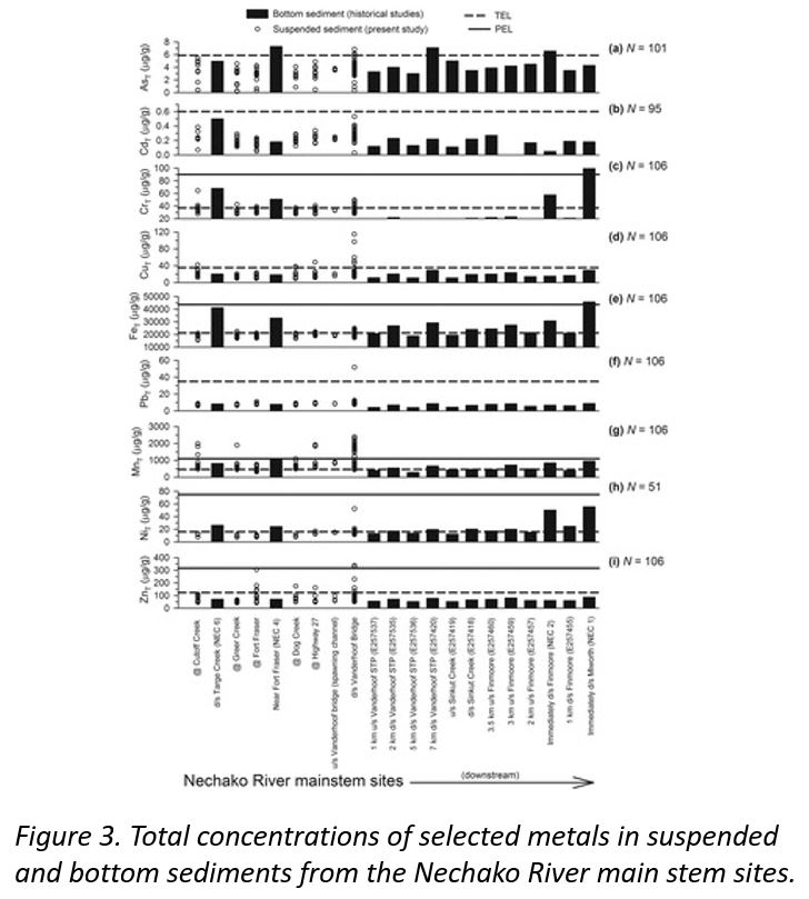
Most all of the compounds we detected in bottom sediments were always well below provincial and federal guidelines for the protection of aquatic life. However, concentrations of some total labile metals in suspended and/or bottom sediments often exceeded provincial threshold effect levels and, in some cases, approached or exceeded probable effect levels (Figure 3). This work raises some concerns regarding organopollutants, metals and perhaps excessive nutrients in the sediments of the Nechako River and its major tributaries and their potential impacts on the reproductive physiology, condition and growth of white sturgeon. This work has also been valuable in helping to interpret our sediment fingerprinting results in terms of the sources of fine sediment.
Phase 2

Research Summary for Polycyclic Aromatic Hydrocarbons in Terrestrial and Aquatic Environments Following Wildfire: a Review
This study assessed existing research on PAH contamination in surface waters and sediments, aiming to create a roadmap for future PAH studies. Findings revealed a scarcity of post-wildfire PAH studies in surface waters and sediments, with the majority of literature focusing on PAHs in soils post-wildfire or sediments in heavily industrial areas. The common use of diagnostic ratios for PAH source determination was noted, but limitations in differentiating between pyrogenic sources were identified. The study advocates for urgent and comprehensive research in post-wildfire aquatic environments.
This study aimed to assess post-wildfire PAH contamination in soils and river sediments, identifying main sources of PAHs. Soil samples from burned and unburned areas in 2018, as well as from burned sites in 2020 and 2021, were analyzed, alongside sediment samples from three tributaries and three main Nechako River locations spanning 2018-2021. Findings revealed a decline in soil PAH levels from 2018 to 2021, remaining higher than in unburned areas, and initial elevated PAH levels in tributary sediments post-fire reversed in subsequent years. The study concludes that wildfires significantly amplify PAH pollution in both land and water, providing surprising insights into PAH sources in the Nechako River and its tributaries for future studies in wildfire-affected watersheds.


Research Summary for Determination of Sediment Sources Following a Major Wildfire and Evaluation of the Use of Color Properties and Polycyclic Aromatic Hydrocarbons (PAHs) as tracers
Sediment sources post the 2018 Shovel Lake wildfire were investigated utilizing colour properties and 16 PAHs. Sampling from 2018-2021 in the Nechako River and tributaries using the MixSIAR model identified burned topsoil as a significant tributary contributor (up to 50%), contrasting with the mainstem Nechako River where banks contributed significantly (up to 89%). While colour tracers yielded more realistic results than PAHs, future research on PAH behaviour is suggested for improved sediment fingerprinting in wildfire-related studies, especially considering the anticipated increase in wildfire size and severity.


